The Omate Valley in Moquegua is the main fruit-growing valley of southern Peru: at 2,160 m above sea level, it was reborn from the ashes of the Huaynaputina volcano in 1600.
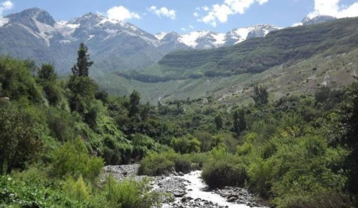
In the heart of the Cordillera Occidental of the Andes, nestled between the Goylanto and Paylogen snowcaps and the Junín and Cerro Blanco hills, the Omate Valley reveals itself as one of the most fertile and authentic landscapes in southern Peru. At 2,160 meters above sea level, in the province of General Sánchez Cerro in the Moquegua region, this inter-Andean valley spans an altitudinal range from 1,500 to 3,900 meters, encompassing the Yunga and Quechua natural zones — where red earth, clear skies, and the murmur of the river set the rhythm of each day.
What makes the Omate Valley truly singular is its status as the main fruit-growing valley of the Moquegua region. With a temperate, dry climate, an average temperature of 16°C, and up to 10 hours of daily sunshine, its hillsides produce limes, avocados, peaches, and figs, along with aromatic plants such as oregano, muña, and mint that perfume the air throughout the year. This is not a mass-tourism destination: it is a place where time moves at the rhythm of the harvests and the flight of condors above the peaks.
Despite its apparent tranquility, the Omate Valley carries an extraordinary history. Its fertile soils are partly a direct legacy of one of the most devastating volcanic eruptions in South American history: the eruption of the Huaynaputina volcano in 1600, which obliterated the valley and seven entire settlements, with climatic consequences felt as far away as Russia.
History of the Omate Valley: Between Civilizations and Ashes
The first inhabitants of the Omate Valley were Aymara communities, whose presence in the area dates back to pre-Hispanic times. With the expansion of the Tahuantinsuyo under Mayta Capac, the Quechua people integrated this region into the Inca system, building agricultural terraces on the hillsides that still structure the landscape today. During the colonial period, the valley became a mandatory route for conquistadors, muleteers, and Creole merchants traveling through the southern Andes.
The most decisive historical event took place on February 19, 1600, when the Huaynaputina volcano — whose name in Quechua means “young volcano” — erupted with unprecedented violence. The eruption produced columns of gas, ash, and pumice rising more than 32 kilometers into the atmosphere and expelled between 13 and 14 km³ of volcanic material. The valley was buried: seven populations were destroyed, and the ash, according to chronicles by the priest Ventura Trávada y Córdova, reached a radius of 2,000 leagues.
The global consequences were equally extraordinary: scientific studies have linked this eruption to a climatic anomaly in the northern hemisphere that caused crop failures across Europe and contributed to the famine of more than 2 million Russians. The Omate Valley survived: its communities rebuilt the territory, and the soils enriched by volcanic ash proved to be the foundation of the fertility that characterizes it to this day.
A Fertile Valley Between Volcanoes and Condors
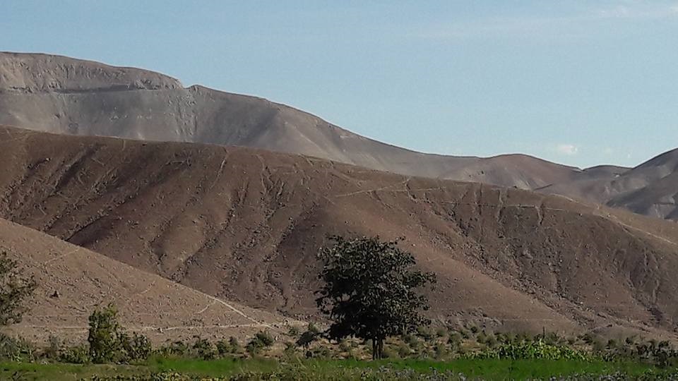
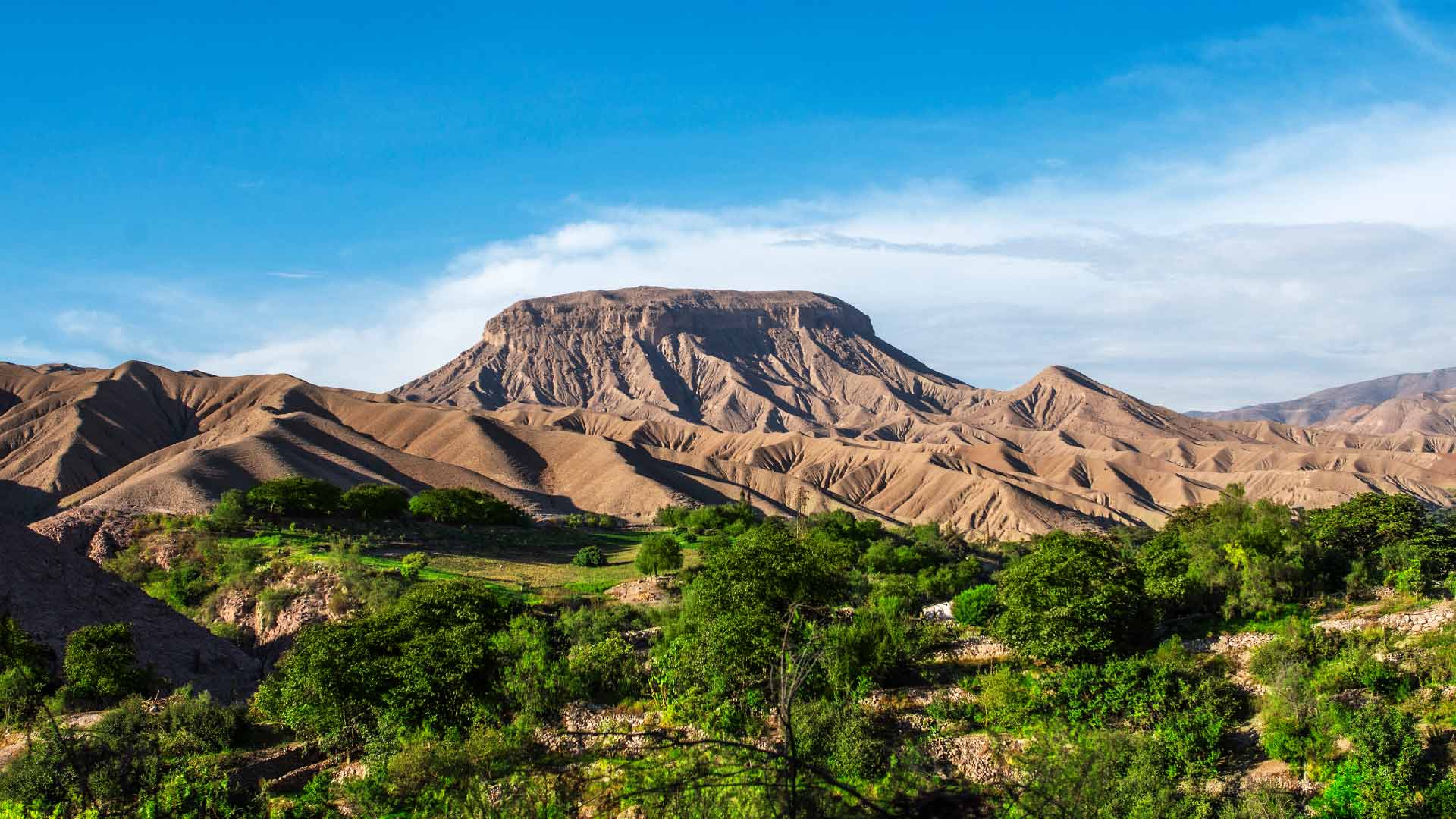
The landscape of the Omate Valley is a synthesis of geological forces and human life. The volcanic geology of the terrain — shaped by centuries of activity from the Huaynaputina and other volcanoes along the southern Andean chain — has given rise to deep, mineralized soils that explain the exuberance of its crops. The 17 populated centers distributed throughout the valley are small nuclei of agrarian life where families cultivate using techniques passed down through generations.
The vegetation blends Yunga species with the higher-altitude Quechua flora: willows, molle trees, fig trees, and algarrobo coexist with fields of limes, avocados, and peaches. At higher elevations, the landscape becomes more austere: ichu grass and aromatic shrubs dominate the hillsides that ascend toward the snowcaps.
The wildlife is equally rich. At higher altitudes, five varieties of doves, eagles, vultures, and — if the moment is right — the majestic flight of condors soaring over the ridgelines can be observed. The Tambo River, which flows through the valley floor, allows for canoeing and the artisan fishing of river shrimp — activities that are part of the everyday life of local communities.
Places of Interest in the Omate Valley
Natural valley viewpoint: From the elevated points that flank the valley, it is possible to contemplate the geometry of the agricultural terraces, the green line of riparian vegetation, and, on clear days, the silhouettes of the volcanoes that frame the southern horizon.
Tambo River: The river that runs through the valley is the setting for adventure tourism in Omate. Its waters allow canoeing in specific stretches, and shrimp fishing is a local tradition that visitors can experience alongside the local communities.
Agricultural terraces: The cultivated terraces on the hillsides are a living legacy of Inca engineering. Walking them on foot offers a privileged perspective of both the landscape and the agricultural activity that still sustains the local economy.
Holy Week in Omate: The town of Omate is recognized throughout the region for its Holy Week celebrations, which combine religious fervor, nighttime processions, and massive community participation. It is one of the most authentic cultural events in southern Peru.
Tips for Your Visit
- The Omate Valley is visitable year-round; the dry season between May and November offers clearer skies and better road conditions.
- Bring layered clothing: mornings and evenings are cold, especially above 2,500 meters, although afternoons can be warm and sunny.
- Some areas are private agricultural land. It is important to coordinate access with local farmers before entering restricted zones.
- The final stretch from Moquegua requires a four-wheel-drive vehicle. Check road conditions before departing.
- For condor watching, dawns in the higher zones offer the best conditions: the thermal currents that form as the valley warms favor the flight of the birds.
- The town of Omate has accommodation, restaurants, banking services, and a pharmacy.
How to Get There
Lima to Moquegua
Intercity bus — approximately 16 hours
Lima to Arequipa (faster alternative)
Flight — approximately 1 hour 30 minutes
Arequipa to Omate
Bus or car — 129 km, approximately 3 hours. Daily service in three shifts.
Moquegua to Omate
Bus or four-wheel-drive vehicle — 147 km, approximately 3 hours. Service three days a week.
Frequently Asked Questions
How much time is needed to visit the Omate Valley?
A full day is sufficient to cover the main points of the valley: the viewpoint, the banks of the Tambo River, and the agricultural terraces. If you want to include excursions to the higher zones for condor watching or longer hikes, it is recommended to stay at least one night in the town of Omate, which has basic accommodation and restaurants.
Can the Omate Valley be visited year-round?
Yes, the valley is visitable throughout the year thanks to its temperate, dry climate. However, the dry season between May and November offers the best conditions: clear skies, better road conditions, and a greater likelihood of spotting condors. During the rainy months (December to March), the vegetation is greener, but some access roads may be affected by landslides.
How is access to the Omate Valley from Moquegua?
The Moquegua–Omate route covers 147 km on a gravel road and requires a four-wheel-drive vehicle on the final stretch. Public transport operates three days a week from the Moquegua terminal, with a travel time of approximately 3 hours. From Arequipa, access is daily and covers 129 km in a similar travel time.
Are tourist guides available in the Omate Valley?
The valley does not yet have a formal offering of certified guides, but in the town of Omate it is possible to hire local guides through guesthouses or the district municipality. For access to private agricultural areas or venturing into the higher parts of the valley, it is highly recommended to go with a local guide familiar with the routes and the communities of the area.
Hours
- 8:00 AM – 4:00 PM
- Free access in public areas; coordinate with local farmers for restricted zones
- (Reference hours)
Admission Price
- Free entry
- (Reference)